Federal Hill Fire Tower

Distance: .4 miles

Difficulty: Easy

Every since I was a young child I have always loved fire towers. The thrill of climbing up to the a tower and the beautiful panoramic views. Growing up in Northern Maine I had access to some pretty good ones.  There are also some great ones in Southern New Hampshire.  

Federall Hill Fire Tower in Milford, NH is a fun one.  The trail head is located on Ponemah Hill Road in Milford.  The access road is gated so you need to park nearby and walk up.  It less than a half mile walk up to the fire tower. The walk is a steady incline up.  

rqtjmSMeSLKgT9LRhQqcgQ.jpg

There is not view from the base of the fire tower.

IMG_3585.JPG

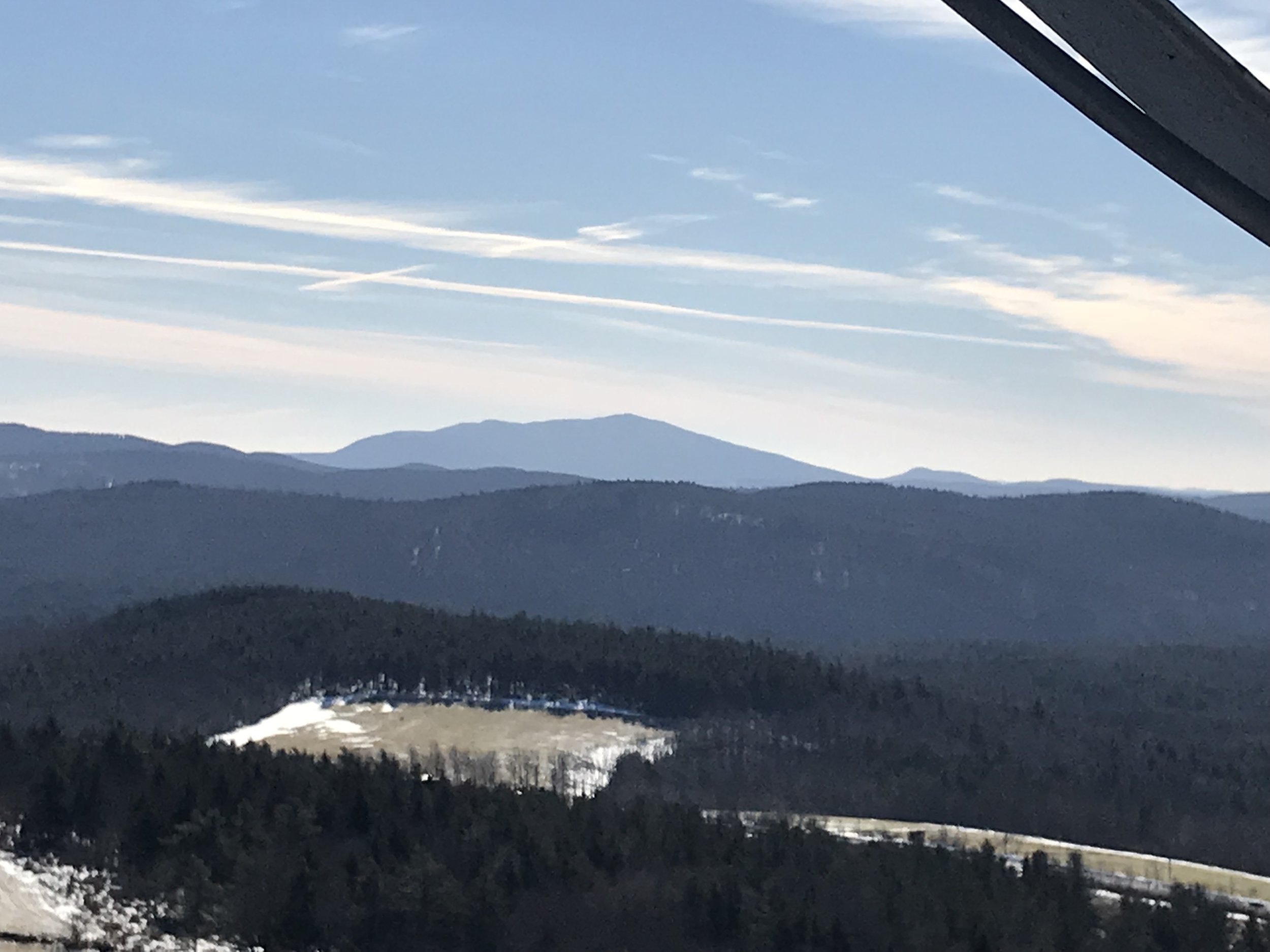
If you climb up it there are beautiful views of Southern NH and the Monadnock Region.  

IMG_0666.JPG

Always use caution when climbing a fire tower to ensure your safety.  Every time we have visited we observed a lot of broken glass around the base. If you are bringing your dog please use caution.  

This is a good fire tower to do if you are working on your Fire Tower Quest Patch.  

HighBridge Hill Storybook Trail

Distance .6 miles

Difficulty: Easy

I am always trying to find ways to engage my daughter to get outside.  One of her favorite type of trails are storybook trails.  I mean, what’s better than encouraging your child to read all while getting fresh air and exercise. 

At HighBridge Hill Elementary School in New Ipswich is a great little storybook Trail.  The trail is open spring, summer and fall, but closed during the winter months. The trail is about .6 miles long. When you turn into Highbridge Hill Elementary School, take a right to drive up towards the fields.  There is a parking lot on top of the hill.  There is a small clump of trees and that is where the trail starts.  From here it is a little confusing, but it goes across the road you drove in on down into the woods.  The trail is easy to follow from there.  You do walk by the schools playground, in case you have a child that is easily distracted by playgrounds. A great way to get your little ones out on the trail. The trail is not stroller friendly.   

IMG_2159.JPG

Andres Institute of Art

Distance: Varies, several loops

Difficulty: Easy side of moderate, trails on the on the side of an old ski mountain.

Andres Institue of Art is a beautiful sculpture park located on Rt 13 in Brookline, NH. Located on the side of an old ski mountain, Big Bear Mountain, Paul Andres purchased the land in 1996. Per their website, their mission is, “Andres Institute of Art shall serve and advance the intellectual and social well being of the public by educating and training artists, by promoting the integration of art and technology, and by supporting fine arts.” 

IMG_4528.JPG

The parking lot has recently been relocated to behind Kun Garden Restaurant. There is a sign marking the parking area.

FD4757C1-5064-405C-8F93-569F6A244666.jpeg

I am not sure of how many miles of trails are located at the institute, but at least a few miles. I recommend printing off or picking up a map of the trails. The trails wind around the side of the mountain. The sculptures are amazing and you can tell a lot of time and dedication go into making and setting them up at the institute.  

IMG_4517.JPG

Once at the top of the mountain there is a beautiful view looking toward the Wapack Range and Mt Monadnock.  

IMAGE.JPG

We have taken our daughter to the sculpture park several times since she was little and she has always been engaged and generally interested the hike. This is huge when hiking with a young child.  Andres Institute of Art is a great hike for groups and families. I have also snowshoed here a few times and it is a great workout and the sculptures are beautiful after a recent snowfall. Do keep in mind that sections of the trails are steep. You can walk trails or up the road.  

IMG_4552.JPG

Loverens Mill Trail

Distance: 3.5 Mile Loop

Difficulty: Easy

The Loverens Mill Hiking Trail is located on Loveren Mill Road off of Route 9 in Antrim. After you turn onto Loverens Mill Road you cross the bridge and the parking lot is located on the right. The trail starts across the street which is marked with a sign from the Nature Conservancy and a trail map.

   From the parking lot you walked up an old road along an old mill and dam site  

IMG_4568.JPG

After walking a few hundred feet the trail turns to the right.  The trail was fairly easy to follow due to trail markers.  Not far down the trail is the side trail through Loverens Mills Cedar Swamp.  Fun fact: "Atlantic white cedar swamps are rare in New Hampshire, comprising only about one percent of the state’s wetlands. Loverens Mills Cedar Swamp is the second largest and considered the highest quality boreal cedar swamp in New Hampshire." Courtesy of the Nature Conservancy Website.  

JZxToO%4S9yJRJkNYkUavQ.jpg

After meandering through the woods you come to a fork in the trail where you can go right or left. I have gone both ways and do not have a preference. If you go right you follow the trail through the woods to the Contoocook River.

KyGOVnJ0S2WElnR2bvRvTA.jpg

There is another side trail to a lookout point that overlooks the rivers and some local ridges.  

IMG_4561.JPG

After the lookout point the trail follows the river for a little bit before turning back into the woods and connecting to the start of the loop.

The total hike was about 3.5 miles it is mostly flat, but there are few gradual inclines and declines throughout the trail. Due to the length and various up and downs of the trail I would recommend this for older kids and people who have some hiking experience. There are a lot of rocks on the trail so you want to make sure have had about a foot of snow if you plan on snowshoeing here.

IMG_4567.JPG

White Ledges

Distance: 1.25 miles roundtrip

Difficulty: Easy

In Temple is a gem of a hike known of the White Ledges. From Route 45 in Temple you turn onto Howard Hill Road and drive a tenth of a mile to the trailhead. Which is an old dirt road. You park on the left side of Howard Hill Road. You walk up the old dirt road. There will be a house on your right as you walk. About a quarter mile down you will come to a gate, which you continue through and up the trail for another quarter mile.

Right before you get to the ledges look off to your left for a view of Pack Monadnock.

7553A629-8360-42DE-9A77-7B83E376AAA6.jpeg

Once at the top there there is a good size out cropping of white rock. This is such a fun place for kids to climb and explore.

IMG_4474.JPG

There is a decent view looking towards Wilton, Milford, Manchester and Nashua.  More recently it has become my favorite place to watch the sunrise.

I have also gone up here to view the moon and star gaze. The trail is only a little over a half mile to the top so it is perfect for children or those looking for a short hike with a great view.

Pitcher Mountain

Distance: .4 miles

Difficult: Easy side of moderate

Sometimes you just need a short hike to get your heart pumping and enjoy some beautiful views no matter the season. Pitcher Mountain is a great short hike for that.

The trailhead is located on Route 123 in Stoddard, NH.  There is a small parking lot and the options of two trails up to the fire tower.  We usually take the old tote road to the top, but there is also another trail, called Blue Trail that you can take.  The tote road is a little rocky, just be cautious of your footing.  If you are hiking in the winter you may need Micro spikes.  

IMG_4493.JPG

It was a little under a half mile to the top where the fire tower is. Both trails are about the same distance. I love the views from the top because on a clear day you can see Mount Monadnock and into the ski mountains of Vermont.  I am not exactly sure how far you can see, but it seems pretty far and for little effort the views are breathtaking.

IMG_4499.JPG

In the spring, fall and winter fire tower is locked as there is no one working there.  The last time I was there in the summer there as a fire tower watch person working.  They were a wealth of knowledge of the various landmarks you can see from the tower.  

IMG_4496.JPG

With the panoramic views it is also a great spot to watch the sunrise and the sunset.

Sunset

This trail is great for children, families, beginner hikers and those just wanted to get out for a quick hike with a great view.    

1C949605-11C4-47A1-8735-A844175393C4.jpg

Shieling Forest Trail

Distance: About a two mile loop.

Difficulty: Easy

Located on Old Street Road in Peterborough, before the roundabout at Monadnock Community Hospital, is a great trail system for families and people looking to get in a short hike.  Shieling Forest is a State Forest that provides a beautiful walk in the forest. There is large parking lot offering plenty of parking. Sometime the building next to the parking lot holds events.

The trails are easy and you can do all of them in less than two hours. From the parking lot you head across a small field to a set of stairs. From here you walk down to a small bridge.

IMG_1802.JPG

Once across the bridge have options to take a few different trails.

BA252FC6-A6E3-4F7A-9839-8790ED9814E5.jpeg

The trails are relatively flat so easy for little legs or someone who wants to get out for an easy hike.

945B06EC-112A-456C-896E-F8A34F696889.jpeg

I like these trails for kids because there is a stream, bridges and large rocks all for exploring. We also saw a couple picnic tables by the stream. A perfect spot for a picnic.  

CD4C7F8C-502C-4F3B-86CD-CC44337B7A1B.jpeg

These are good trails for hiking and snowshoeing. Sometimes the trails are closed so make sure you read the sign out front before exploring the trails.  This trail is located on the Brews and Views Challenge. If you like beer and are able to stop, check out Post and Beam Brewery while you are in the area.

Gilson Pond Trail

Distance: 1.5 miles loop

Difficulty: Easy

Fee for Day use

Gilson Pond is an easy hike around a pretty pond with views of Mt Monadnock. To access the trail, park in the parking lot for Monadnock State Park/Gilson Pond Campground across from Thorndike Pond Beach on Dublin Road in Jaffrey, NH. There are several trails around the campground and park with many that lead up to Mount Monadnock.

5AAF4FAA-D1F5-47C8-97A6-B4F86390AA9D.jpeg

The Pond Loop starts a little past the toll booth. You will see the sign above and the pond on the right. The trail is flat and easily to navigate with blue trail markers on the trees.

556E281A-8A7D-4B99-ACE4-7B51B2CF4501.jpeg

The Pond Trail Loop around Gilson Pond is a great little hike or snowshoe anytime of year.  The trail takes you around the whole pond providing a variety of great water views.

IMG_4375.JPG

At parts of the trail you get partial views of Mount Monadnock  

48983FE9-982C-4A4E-AFEF-EC9B54CBA762.jpeg

There are several foot bridges to cross, which are always fun. I have observed cross country ski tracks and signs on the trail during the winter months. You would have to be a decent cross country skier to ski here due to the trees and curves in the trail.

IMG_4374.JPG


The Gilson Pond trail is a great hiking trail for year round hiking, beginner hikers, snowshoers and those who just want to get outside for about an hour  

Giant Ice Marbles

Winter in New England can be difficult.  It is ever changing and it can be balmy with minimal snow or have large quantities of snow and below zero temperatures. With cold temperatures it can make it difficult to get outside especially with little ones.  I am always looking for new activities to keep my daughter entertained during the cold days when it is not safe to be outside for too long.  Thanks to Vermont State Park Blog I found something fun and colorful to do.  

Giant Ice Marbles.  I have seen these around the internet over the last couples years, but have not tried them.  With our family being on vacation this week and below zero temperatures I was looking for something to do so when a blog from Vermont State Park's popped up on Facebook about making these and I thought it was a perfect time to make them.  

All you need is:

  • Ballons

  • Food coloring

  • A faucet with running water

IMG_4324.JPG

If your child is able have them drop as many drops of food coloring into the ballon while an adult holds it.  Then the adult takes the balloon and puts it over the faucet to fill the balloon up with water.  Try not to fill the balloons too much or they could pop and you could have colored water all over the place. Tie the balloon off trying to release as much air as possible.  One step that I did not do, that I should have, was shake them up to mix the food coloring around the balloon. After you have done your desired amount, we did eight.  Set them outside for 12-24 hours to freeze.  

IMG_4327.JPG

Once they are frozen peel off the balloons and decorate your yard with beautiful ice marbles. I would recommend wearing disposable gloves when peeling the balloons off as my hands got covered with food coloring. Perfect for all ages with adult supervision and brings a pop of color to your yard.  

IMG_4347.JPG

Heald Tract

Distance: Varies

Difficulty: Easy

Everyone has that one trail that is their go to trail.  A trail that is accessible all year round, close to where you live and provides you that sense of satisfaction with being outside without having to drive long distances.  The Heald Tract does just that for my family and I. We have been hiking this trail since we moved to the area.

IMG_4431.JPG

Located on Heald Road in Wilton is a series of trails known as the Heald Tract.  This is conservation land owned by the Society for the Protection of New Hampshire Forests and is it perfect for year round activities like hiking, fishing, snow shoeing, wildlife viewing and cross country skiing.

kDBQ7K+ASEKqtT+S89UoVg.jpg

    There are a few different trails with minimal elevation gain. My favorite trail is King Brook Reservoir.

IMG_1409.JPG

Camp Trail and Caster Pond Loop have also become a favorite of ours especially in the winter months. The Camp Trail goes by an abandon camp that has since burned down, but there is an old firepit that when there is snow on the ground is perfect for a winter fire.

63D851CA-D929-4531-B568-6FB6431DC64B.jpeg

There are also some beautiful ponds, streams and trails.

5FAE0C54-31B5-4666-A943-72628E5E1B36.jpeg

There is also several rock walls and cool cellar holes.

94E853D5-5561-425B-BC00-F8AFF580DF6F.jpeg

Recently they have been doing some clearcutting and it has affected some of the trails. I have seen signs up if the trails are closed. I recommend bringing the trail map if you haven’t been there before. These trails are good for all abilities and age levels. We have not found a bad trail around the Heald Tract.

Florence Roberts Forest

Distance: 1-2 Miles

Difficulty: difficult to Navigate

Sometimes not all trails are good and worth visiting again, which saddens me.  In the words of my husband, "not all trails are good and you have found some pretty great ones." This past weekend I had that experience.  I have driven by Florence Roberts Forest across from Uncle Sam's House on Rt 123 in Mason, NH many times. I have been curious about these trails, but never stopped to explore them.  I have tried to google information on them, but have never found any information about them.  After a group hike this weekend I felt guilty for not taking my dog for a walk so I thought it would be a perfect time to check out the trail.  

IMG_3985.jpg

The kiosk at the entrance has limited information.  At one time there were maps, but there were none the day I visited.  There are two trails at the small parking lot, I chose to take the one off to the right.  At first the trail was very easy to follow with trail markers on the trees.  There were also numbers, not in order, my guess for some form of information on the trail.  At the top of a small hill was a bench.  I continued along the path along a ridge line.  There was not much of a view from the top.  As the trail headed back down the ridge there was a beautiful rock wall.  

IMG_3991.jpg

At the bottom of the ridge is where the trail started to get confusing.  There appeared to be a series of blow downs and the trail was marked with flagging. On one side of the trail was a steep rock formation and on the other side some water.  With the blow downs and limited trail markings it was very difficult to navigate the trail and walk, not making for an enjoyable hike.  After about a quarter of a mile I was able to bush wack my way back out to the trail I had started on.  When I got back to my car I walked a few hundred feet along the second trail, but also found that difficult to navigate with very limited trail markers.  

IMG_3992.jpg

Unfortunately,  I would not recommend this trail to others as it not well marked or maintained. If you did not know the area or have difficulty navigating in the woods this trail would not be good for you.   

Cranberry Meadow Pond Trail

Distance: 1 Miles

Difficulty: Easy

Located on Old Street Road in Peterborough, NH, near route 101 is a wonderful hiking trail that is perfect for all abilities or if you just want to get out into the woods for an hour.  The trail starts out by going over several foot bridges.

A0E4DA93-BA8A-445A-B5AC-BB43A403B8F4.jpeg

Then meanders through the woods along a stream. During the summer months the stream can be pretty low, but in the spring there is a nice flow with small cascades.

IMG_3748.jpg

When you get closer to pond there is a small incline and then a decent down to the pond.  

IMG_3761.jpg

On the way back from the pond, when the leaves are off the trees you can get a glimpse of Mt. Monadnock.

D3A77DA7-AC96-4189-A24A-6498943DAD26.jpeg


The hike is about a mile to the pond, but you can continue a little over a mile to East Mountain Road. From there you can connect to a trail that goes up Pack Monadnock.  I have only walked to the pond, therefore I can not comment on the rest of the trail. In the wet season the trail does have some muddy spots. I recommend this hike for all ages and abilities.  


Ponemah Bog Wildlife Sanctuary

Distance: About a mile

Difficulty: Easy

No dogs allowed

Every Thanksgiving we head out for a hike in preparation for all the yummy food ahead.  This year was no different. Since I was cooking  we needed shorter hike.  Ponemah Bog in Amherst, NH is something I’ve heard a lot about and have been wanting to check out.  Usually when I think of a hiking, I'm heading north or west.  I never think to look around Amherst, NH.  With the trail being so close to a main road, I was a little skeptical if I would feel enough in the woods to enjoy myself, but to my surprise, my family and I really like this trail.

IMG_3908.jpg

The trail itself is located on Rhodora Drive off of Stearns Drive in Amherst, NH. There is a sign marking the trail and a decent size parking lot.  There are no dogs allowed so please leave your four legged friends a home.  The trail is a loop.  We started out by walking the boardwalk through the forest and a bog and ending up at a small pond.  

IMG_3896.jpg

Along the pond are bird houses, various lookouts with benches and opportunities for wildlife watching. As you are circling back around the bog to the parking lot there is a raised platform overlooking the bog.  My daughter loved this and felt like she was in a treehouse.  

The one downside to the walk was the boardwalk was very slippery from all the rain from the day before and below freezing temperatures over night.  Over all we loved the walk and would highly recommend this for families or for someone who lives in the area and wants a few minutes outside without having to drive long distances.   

IMG_3912.jpg

Beaver Brook Trails at Maple Hill Farm

Distance: Varies

Difficulty: Easy

Mother Nature played a good April Fool’s joke on us in 2017, dropping about a foot of snow in the Monadnock Region.  Just as we were getting ready to put our snow gear away, winter is back in full force.  Knowing the snow would not last long we ventured out to Beaver Brook Association in Hollis, NH to explore the trails on cross country skis. 

When my husband and I were first dating and lived in Nashua, we frequented these trails as they gave us the opportunity to spend time in nature without driving long distances.  Returning to these trails with our daughter allowed us to share with her some of our earlier memories in our relationship and our love of the outdoors.

 
Beaver Brook is a great place to visit for all ages and abilities. They offer an array of activities such as school activities, a fitness group, a treasure hunt for kids, bird watching, gardens, various presentations, nature identification markers along some of the trails, as well as miles of well marked trails for hiking, mountain biking, snowshoeing and cross country skiing. We also saw deer tracks and could hear various birds chirping. 
The day of our visit we chose to ski a three mile loop.  These trails are multi use so there are no groomed trails, but due to the amount of traffic the trail was packed down enough to get a good glide. 

The second half of the loop was a little more backcountry skiing than we expected, but my husband and I were really proud with how well our daughter did meandering through the trees, up and down hills and over small streams. 

IMG_1211.JPG


Recently, I had seen a Facebook post about a wigwam on one of their trails.  I wanted my daughter to check it out.  This is such a fun little area, there is a small wigwam that fits a few people and allow little ones minds to imagine.  There is also a small stream and a bridge, that I imagine in the spring and summer is great for throwing rocks in.    


If you are in the Nashua area and are looking for a great place to get out into the wood for a few hours, I high recommend that you checking out Beaver Brook Association.

Grafton Outdoors Center

It was the last day of winter of 2017. The winter had had it's up and down in terms of snow fall, limiting how often we were able get out and enjoy winter activities.  With a recent blizzard providing us with well over a foot of snow, I wanted to get out and enjoy what could possible be the last snow of the season.  We have done a lot of repeat activities this winter, skiing the same places and hiking the same trails so I wanted to try a different area in New England.  This is always the difficult part as I never want to spend too much time in the car. After various google searches I decided to take the family cross country skiing to Grafton Outdoors Center In Grafton, Vermont. 

Grafton is located about an hour and a half away from Peterborough, NH.  Grafton is a typical Vermont town, with a local inn, general store, cheese shop and restaurants with fresh local food.  Upon arrival to the outdoors center, you observe a beautiful view as it is nestled among various mountains, a mountain stream and some fields. There is a small lodge where you can rent cross country skis, snowshoes, fat bikes and tubes for sledding. They sell some food and drinks or you can bring your own lunch to enjoy in front of the roaring fireplace.  In the summer, they have other activities such as swimming, disc golf, hiking and mountain biking.  

We spent a couple hours exploring their trails.  They had a great set up for beginners or children just getting into cross country skiing as most of the trails were relatively flat.  The blue trails, which are moderate, we found very manageable for our seven year old.  We explored the forest, some fun hills, a couple fields, a covered bridge, a mountain stream and a cheese factory.  Yes, you can ski to a cheese factory.  Unfortunately, the factory was not open the day we visited, but the general store a couple miles away sold the cheese from the factory.

Skiing

After exploring the trails, my daughter wanted to test out the tubing hill. We rented a tube and headed towards the hill.  This was the only negative of the trip.  You have to walk the tube up the hill and after a couple hours of skiing and walking up the hill our legs got tired quickly.  I know other tubing facilities have some sort of tow or magic carpet, which would have been nice here.  My husband and I took turns going up and down the hill and getting our steps in for the day.  The first run I was a little nervous watching my daughter go down as it was FAST, but she LOVED IT.  She did about 10 runs before leaving. 

Tubing Hill

Overall, we spent about three to four hours at the facility and would go back. If you are looking for some place different to ski, but is not too far away this is a great place to check out for people of all ages and abilities.  

Forest Bells

Distance: .75 Miles

Difficulty: Easy

In Groton, Massachusetts is a magical little place guaranteed to stimulate little minds and get families outside for a little musical fun. Forest Bells is located in Groton Conservation Land.  


 "The Forest Bells were created by local artist and craftsman Paul Matisse in 1995, commissioned by the inaugural Artist’s Valentine project, and installed on land owned by Arthur and Camilla Blackman.  The Blackman's donated the land to the GCT in 2000, and the Trust has been the steward of the land and bells since then." (from Groton Conservation Trust website)

IMG_0461.JPG

Park at the end of Indian Hill Road, but not too close to the house at the end of the road, we parked on the side of the road.  Walk back towards the house at the end of the road and bare left into the woods past the Groton Conservation Trust sign. This appears to be an old tote road. Head down the path under the power lines past a beautiful wetland area. Make sure you stop and enjoy the view.  We were able to see several birds nests high in the trees.

Birds Nest

The water was overflowing onto the trail, causing it to be muddy so make sure you wear appropriate foot wear.  After the wetlands there is a split in the trail, bear left and walk uphill another 5-10 minutes until you reach the bells. It appears there has been some heavy equipment on and around the trail so make sure you pay attention to your surroundings.  The trail is not marked, but you can follow the foot traffic. Once arriving at the bells we spotted six bells located high in the trees to be played for your musical pleasure.  

Bells

There are also two tee pees made from falling trees and some rocks that is fun for little ones to explore.  We spent about 30-45 minutes exploring the tee pees, climbing on rocks and ringing bells.  There is also a pretty view over looking a wetland.

Teepee

As for the first wetland I suspect this could be a good place for animal watching. This is not a long hike, as it's about 1.25 miles round trip, but this is a great opportunity to get families outside as there is a fun reward at the end. The key to getting kids to enjoy the outdoors is to incorporate fun while outside and this is a great place to do it, playing music, hanging out in the tee pees, climbing on the rocks or bringing a picnic to enjoy the great outdoors. Recommended for all abilities.  


Kidder Mountain

Distance: 1.5 Miles

Difficulty: Easy side of moderate

Located on Rt 123/124 across from the old Windblown Ski area is the trailhead to Kidder Mountain located off the Wapack Trail.  In the last couple years they have created a new parking lot, which a Wapack sign.  

From the parking lot follow the triangles to the powers lines. Once at the power line, instead of continuing straight towards Sharon Ledges you take a right and walk up the power line road until you see a small sign on the left for Kidder Mountain.  

Sign

This trail goes over some small rocks, with glimpses of Mt. Monadnock to your left. You will walk by some large flower pots that were supposedly brought up there for a wedding. I have seen flowers in the pots from time to time. From the pots it is a short distance to the top.

My dog loves the trail too

The total distance is a mile and a half. We love this hike because this is the first mountain my daughter hiked on her own, days before her second birthday, it's close to our home and provides a great view.  The views from the top are beautiful you can see Wachusett Ski area, parts of Massachusetts, Mount Monadnock and the mountains of the Wapack Trail. On a clear day you can see the sky line of Boston.

Looking towards Mt. Watatic in MA

This trail is recommended for all abilities as it's a gradual climb to the top.  

Tucker Brook Falls

Distance: 1 Mile loop

Difficulty: Easy

Tucker Brook Falls is a hidden gem located in Milford, New Hampshire. The waterfall is located in Tucker Brook Town Forest. The trailhead is on Savage Road. There is a small parking lot under the power lines.

There are two options for this waterfall. You can walk a mile loop that ends at the waterfall. Or you can walk about a quarter of a mile to the waterfall. There is a trail map as there are other connecting trails.

I enjoy doing the Falls Loop trail. From the parking lot you head up along the power lines and through the woods. They have been doing some forestry work near the trail.

The trail then follows Tucker Brook until you reach Tucker Brook Falls.

Jw9qv5pkThmmWLxWavSsNQ.jpg

From the falls you walk along the brook and bare right up a steep hill back to the parking lot.

For this falls being in Milford, I am quite impressed with Tucker Brook Falls.  If you are looking to enjoy a little peace and quiet in front of a waterfall without having to drive to north, I highly recommend this little waterfall wonder in Milford.


Casalis State Forest

Distance: 2.5-3.5 Loop

Difficulty: Easy

Located on Route 123 in Peterborough is Casalis State Forest.   The trail starts past the gate. After descending from the parking lot you come to a beaver pond.  This is a great opportunity to catch a glimpse of some wildlife, as there are several bird boxes. 

Beaver Pond

After leaving the pond you start up slight incline to a junction the trail.

22B324F4-3544-4E06-8F09-4C7E04B09BDF.jpeg

If you go left this is a loop through the woods. About a half mile along the trail there is another split.  You can go can either way as this is where the loop starts and ends.

If you so straight you come to a stream. You can cross the stream and I believe this trails connects to the Bass Brook Trail, but I have not explored that trail yet. If you take a left the trail follows the stream. There are some beautiful cascades.

8BB94321-C3E9-4FF8-98D4-A6BEBE8D68CE.jpeg

And signs of an old bridge.

82C79C64-1F64-46DA-BF8F-317996F4D89A.jpeg

Right after the bridge you walk up a slight hill and connect to the loop if you would have gone to the left. To continue around the loop take a right. To head directly back to the trail junction take a left. If you continue around the loop there is a side trail to the right that goes to Condy Road in Peterborough. Continue baring left to finish the loop.

The trail is between two and half and three and a half miles long depending on which way you go. This trail is great for all seasons, hiking, snow shoeing and cross country skiing.  The trail is relatively flat with some small inclines. This is also a popular with mountain bikers. All ages and abilities recommended.